Morning Weather - March 5 - Wally's Weather Australia
- Mar 4, 2024
- 5 min read
To get your daily forecast delivered free goto http://wallysweather.com.au/blog
Thank you to our supporter Learning Lair


We are a small locally owned business with a love of learning and fun. The learning Lair also stock the Dam Filler educational game designed and built by Wally's Weather.
Phone: 07 4755 1544
Facebook: https://www.facebook.com/profile.php?id=100057298906383
Email: llair@bigpond.net.au
Welcome March
National
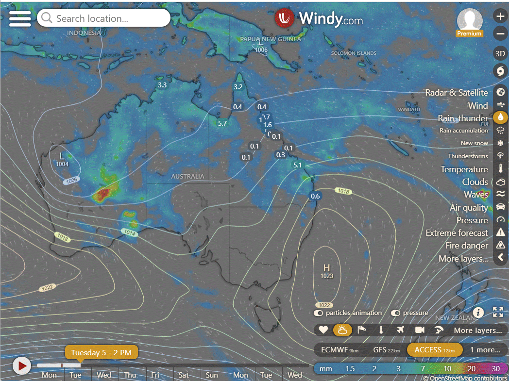
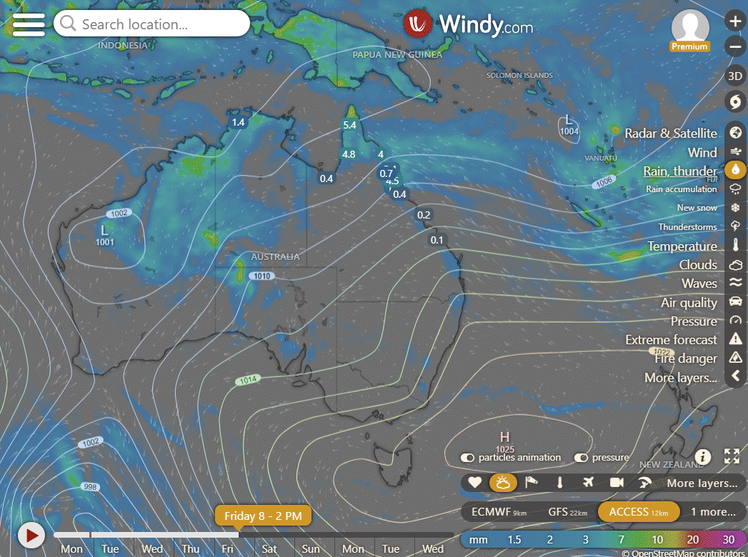
Showers and storms expected across broad areas of QLD, the tropics, WA, and western SA, fueled by moist and unstable winds feeding troughs. Heaviest showers and storms anticipated in WA. Showers to ease in NE NSW and SE QLD as a high-pressure system takes over, while highs elsewhere keep conditions largely dry.
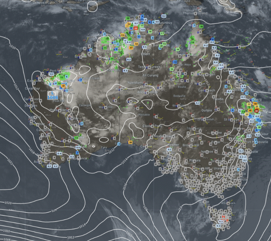

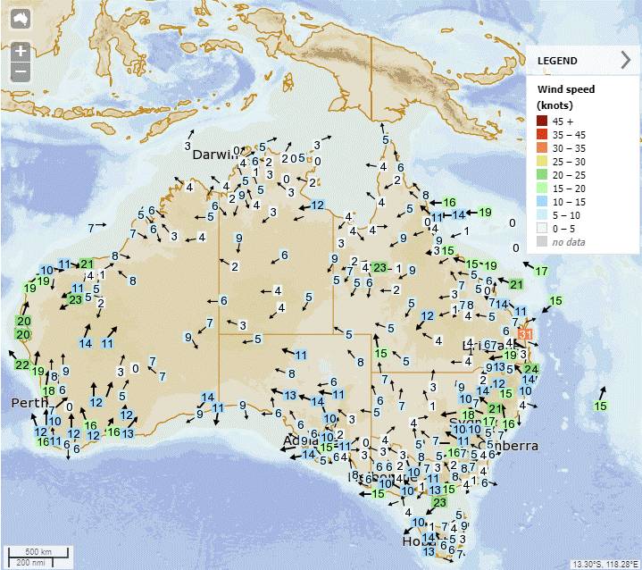
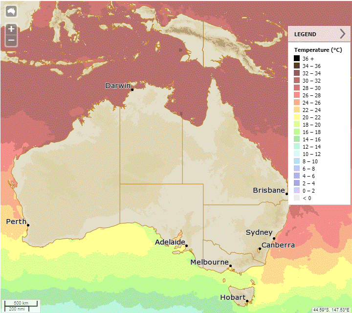
Synoptic | Temp/Rain | Wind | Sea Surface Temp
State
Weak trough near northern Queensland causes showers, storms. Trough moving north over central Queensland sparks severe storms, showers. New high near Tasmania leads to southeasterly wind surge, increasing rainfall along east coast.
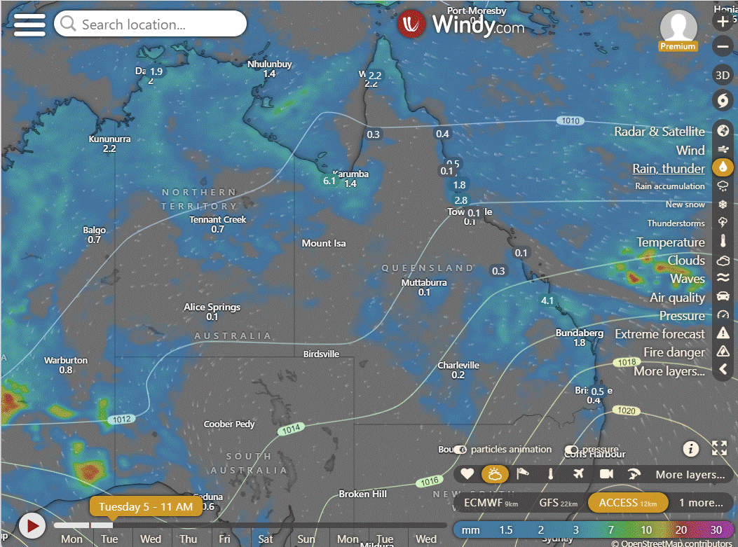
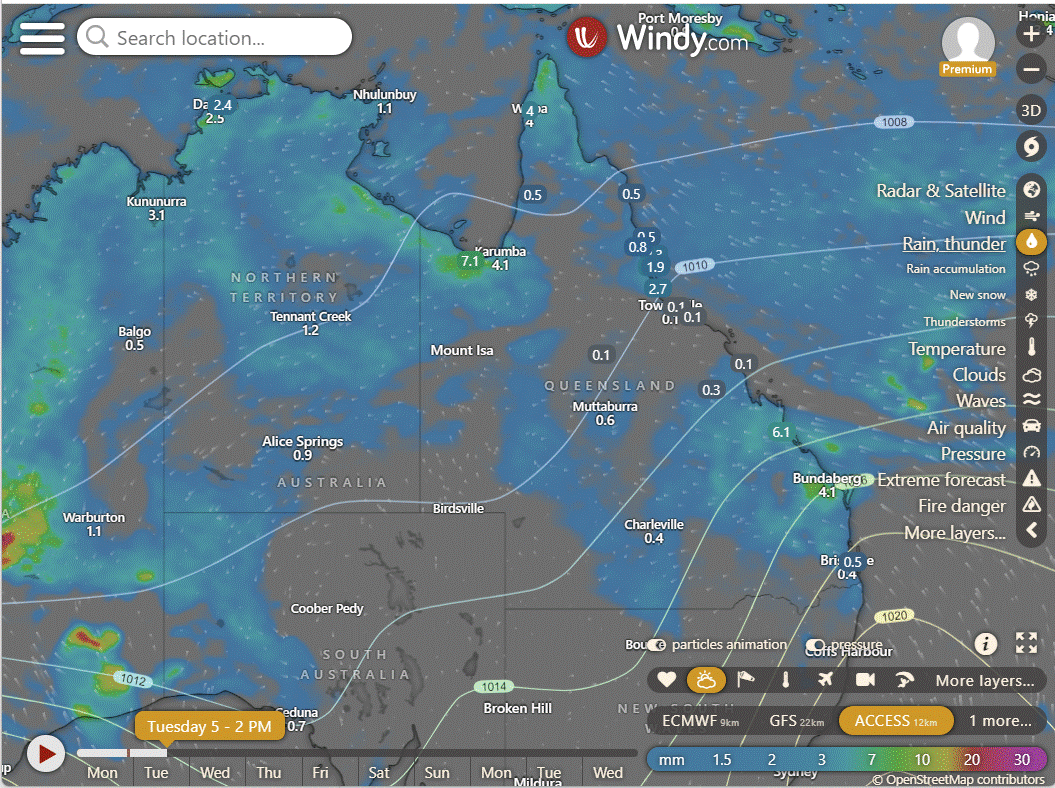
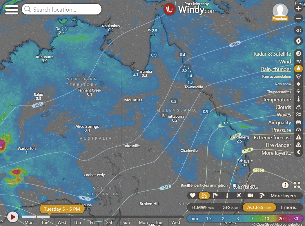

ACCESS (Values are rainfall over 3 hours)
4-day
Tuesday: Mainly sunny in southwest, scattered showers and isolated storms elsewhere, turning to showers in the east between Cooktown and St Lawrence. Severe storms possible in the eastern interior. Light to moderate winds from northeast to southeast.
Wednesday: Sunny in southern areas, showers elsewhere. Above average temperatures in the southwest, near average elsewhere.
Thursday: Showers and storms in parts of Peninsula and Gulf Country. Rain possible in north and far east, becoming widespread in North Tropical Coast. Above average temperatures in southwest, near average elsewhere.
Friday: Spotty rain and thunderstorms in some areas, becoming more widespread along the North Tropical Coast. Warmer temperatures in the southwest, average elsewhere.


North Tropical Coast and Tablelands:
Max temperature: 32°C, Min temperature: Low to mid 20s, Wind: East to southeasterly 15 to 25 km/h, Rainfall: High chance of showers, Other: Partly cloudy with the chance of a thunderstorm.
Herbert and Lower Burdekin:
The weather will be partly cloudy with high chance of showers in the north and medium chance elsewhere, a chance of thunderstorm inland, light winds becoming easterly 15 to 25 km/h in the morning then becoming light in the late evening, with overnight temperatures falling to the low to mid 20s and daytime temperatures reaching around 30.
Central Coast and Whitsundays:
Max temperature: 34°C, Min temperature: 20°C, Wind speed: 15-25 km/h, Wind direction: East to southeasterly, Rainfall: Medium chance of showers, Other: Partly cloudy with a chance of thunderstorm.
Peninsula:
High: low to mid 30s, Low: mid 20s, Wind: Light becoming easterly 15 to 20 km/h, Rainfall: High chance of showers, Thunderstorm possible, Partly cloudy.
Gulf Country:
The weather forecast includes a max temperature in the low to mid 30s, a minimum temperature in the mid 20s, light winds, high chance of showers and a thunderstorm, and partly cloudy conditions.
Northern Goldfields and Upper Flinders:
Max temperature: low to mid 30s, Min temperature: low to mid 20s, Wind speed: east to northeasterly 15 to 20 km/h becoming light, Wind direction: east to northeasterly, Rainfall: High chance of showers in the north, medium chance elsewhere, Other: Partly cloudy with a chance of thunderstorms.
Capricornia:
Max temperature: around 30 degrees, Min temperature: low 20s, Wind speed: 15 to 25 km/h easterly to southeasterly, Wind direction: east to southeasterly, Rainfall: high chance of showers, Thunderstorm: possible, Other: Partly cloudy with showers likely in the late morning and afternoon.
Central Highlands and Coalfields:
The weather will have temperatures reaching 29 to 34, overnight temperatures falling to between 19 and 23, light winds becoming easterly 15 to 25 km/h, medium chance of showers most likely in the morning and afternoon, chance of a thunderstorm, and partly cloudy conditions.
Central West:
The weather forecast includes high to low 30s, low to mid 20s, 15 to 25 km/h east to northeasterly winds, slight chance of showers, possible thunderstorm, and partly cloudy conditions.
North West:
Max temperature in the mid to high 30s, min temperature in the mid 20s, light winds becoming east to northeasterly 15 to 20 km/h, slight chance of showers, partly cloudy with a chance of thunderstorms.
Channel Country:
The weather will be hot with near zero chance of rain, mostly sunny with a slight risk of showers in the northeast, and possible thunderstorms later; max temp around 40°C, min temp in the mid to high 20s, wind speed 15-20 km/h east to southeast, shifting to east to northeast during the day.
Maranoa and Warrego:
Max temperature: 37°C, Min temperature: 19°C, Wind speed: 20-30 km/h, Wind direction: East to northeasterly, Rainfall: Slight chance of a shower in the northeast, Partly cloudy with chance of thunderstorm.
Darling Downs and Granite Belt:
Maximum temperature: 35°C, Minimum temperature: 18°C, Wind speed: 20-30 km/h, Wind direction: East to northeasterly, Rainfall: Slight chance of showers, Other: Partly cloudy with thunderstorm in the north.
Wide Bay and Burnett:
Max temperature: 30°C, Min temperature: 19-22°C, Wind speed: 20-30 km/h ESE, Wind direction: East to southeasterly, Rainfall: Very high chance of showers, Other: Partly cloudy with a medium chance of showers and thunderstorms.
Southeast Coast:
Max temperature: mid to high 20s, Min temperature: 18-22, Wind speed: southeasterly 20-30 km/h becoming light, Wind direction: southeasterly, Rainfall: Medium chance of showers, scattered thunderstorms in the north morning and afternoon, Partly cloudy.
WEATHER WARNINGS
Strong Wind Warning for Byron Coast.
Hazardous Surf Warning for Byron, Coffs, Macquarie, Hunter, Sydney, Illawarra, Batemans, and Eden coasts.
Severe Thunderstorm Warning (Heavy Rainfall and Damaging Winds) for parts of Goldfields district.
Strong Wind Warning for Sunshine Coast Waters and Gold Coast Waters.
Severe Thunderstorm Warning for Southeast Queensland for Sunshine Coast and Noosa Council Areas.
Severe Thunderstorm Warning (Damaging Winds and Heavy Rainfall) for parts of Pilbara, Gascoyne, Goldfields, and South Interior districts.
Severe Thunderstorm Warning (Heavy Rainfall) for parts of Southeast Coast.
Fire Weather Warning for Brockman.
Strong Wind Warning for Perth Local Waters & Ningaloo, Gascoyne, Geraldton, Lancelin, Perth, and Bunbury Geographe coasts.
Final Gale Warning for Southeastern and Southern Areas.
Flood Watch For The Salt Lake District And Nullarbor District Rivers And Sandy Desert.
Initial Minor Flood Warning For The Paroo River (Qld).
Moderate Flood Warning For The Diamantina River.
Moderate Flood Warning For The Flinders Rivers.
Flood Warning For The Inland Rivers Sa.
Minor Flood Warning For The Paroo River (Nsw).
Flood Watch For The Tanami Desert.
Moderate Flood Warning For Eyre Creek And Minor Flood Warning For The Georgina River.
Sheep Graziers Warning for South East.

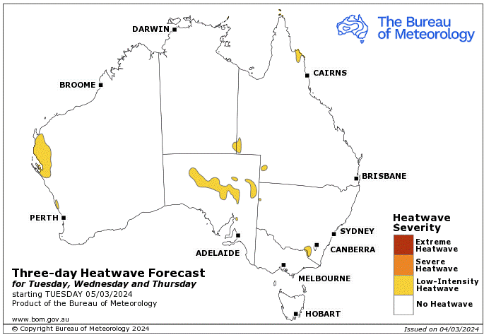
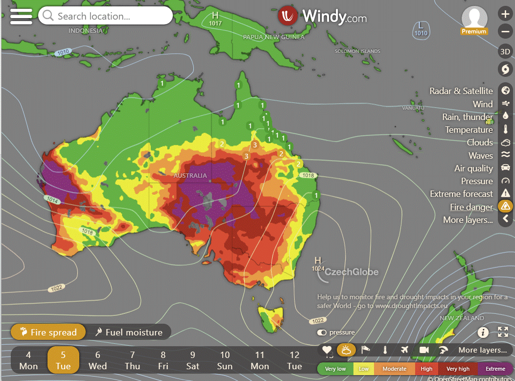
Storms - Heatwave - Fire danger
Click here to support to Wally's Weather
National maps by Weatherzone (weatherzone.com.au)
State maps by Windy (Windy.com)
Weather forecast supplemented by Bureau of Meteorology (bom.gov.au)
Rainfall daily totals (https://meteologix.com/ )
AccuWeather (https://www.accuweather.com/)
Nine Weather (https://www.9news.com.au/weather)
Wally's Weather provides professionally researched data and information. Andrew aka 'Wally' has over 20 years of experience in meteorology research and data analysis. In 2023 finished top 4 for the AMOS national weather forecasting competition. The content here is provided as educational information aimed at providing the community and businesses with the tools required to determine local-based forecasts. IMPORTANT: The forecasts and information posted should never be used on their own to make business decisions as local influences.


Comments