Morning Weather - November 23 - Wally's Weather Australia
- Nov 23, 2023
- 5 min read
This weather update is brought to you by Genesis Electrical NQ

Genesis Electrical NQ
We can Solve all of your Electrical, Air Conditioning and Solar needs!
Green Energy Initiative
Phone: 1300 443 637
Email: info@genesislec.com
Storms special report
A trough over the eastern inland will maintain rain and storms in the north and over southern Queensland, with showers easing for southern New South Wales. Troughs extending over the north and west will trigger showers and storms across the tropics and inland Northern Territory, while driving heat over southwest Western Australia. Storms crossing the dividing ranges and some generating over coastal region mountains. Showers may approach from the Coral Sea from trade winds, however storms will likely shear away from the coast, meaning rain will not move towards the coast from the storm activity.
WEATHER WARNINGS:
Severe Thunderstorm Warning (Heavy Rain) for Central Highlands & Coalfields, Central West, Maranoa & Warrego, Darling Downs & Granite Belt.
Severe Weather Warning (Damaging Winds) for parts of Lower West and South West districts.
Strong Wind Warning Tuesday for Bunbury Geographe, Leeuwin, Albany & Esperance coasts. Cancelled for Geraldton, Lancelin & Eucla coasts.
Downy Mildew Advice for Wednesday for Mid North, Mount Lofty Ranges, Riverland, Murraylands, Upper South East, and Lower South East.
Strong Wind Warning for Spencer Gulf, St Vincent, Invest St & S Cent & Upper SE Coasts. Cancelled for Adelaide Waters & Upper West & L West Coasts.
Gale Warning for Southeastern And Southern Areas.
Fire Weather Warning for Inland Central West, Lower West Inland, Brockman, and Mortlock.
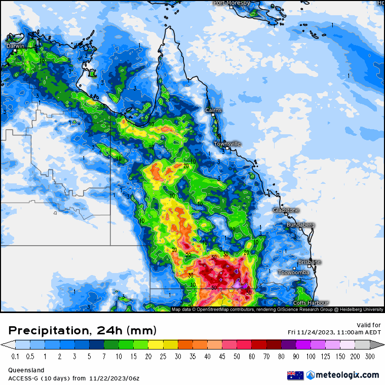
ECMWF Storm 2pm | ECMWF Accumulated Rain 3 Days | ACCESS QLD 8 x 24 hour Rainfall


National
High pressure system over Tasman Sea brings humid air to western Queensland. Stagnant pattern with above-average moisture. Upper troughs move east across southern Australia, causing unsettled weather. Trough may push into eastern districts next week.


State
High pressure over the Tasman Sea is bringing humid air to western Queensland. This pattern will last for days, keeping moisture above average. Upper troughs moving across southern Australia will cause unsettled weather in the interior. The unsettled weather may move into eastern districts next week.


4-day
Thursday: Eastern districts have isolated showers, South East Coast has scattered showers. Inland Queensland has scattered showers and thunderstorms, far western Queensland has isolated showers. The interior has widespread shower and thunderstorms, possibly heavy. Winds are light to moderate, east to northeasterly, but south to southeasterly in the Channel Country.
Friday: Eastern districts and the Darling Downs will have isolated showers while the North Tropical Coast and Mackay Coast will have scattered showers. The interior and Gulf Country will experience scattered showers and thunderstorms, while the far Southwest will have isolated showers. There is a possibility of severe thunderstorms in the southwest. Maximum temperatures will be below average, with central west and northwest expected to be well below average.
Saturday: Sat: Some showers in east and Darling Downs, scattered in North and Far North Queensland. Showers and thunderstorms in interior and Gulf Country, isolated in far southwest. Possible severe thunderstorm in central and southern interior. Below average temps in northwest and central/southern interior.
Sunday: Isolated showers and thunderstorms in the interior, scattered in the northwest and Gulf Country. Isolated showers on the east coast, scattered north of St Lawrence. Severe thunderstorm possible in western Queensland, uncertain areas of focus. Max temperatures below average in northwest QLD.


North Tropical Coast and Tablelands: Partly cloudy. Medium chance of showers. Chance of a thunderstorm in the south. Winds easterly 15 to 25 km/h. Overnight temperatures falling to 18-23 with daytime temperatures reaching 28 to 33.
Herbert and Lower Burdekin (Townsville): Partly cloudy. Medium chance of showers, most likely in the morning and afternoon. Chance of a thunderstorm. Winds easterly 15 to 25 km/h. Overnight temperatures falling to 19-23 with daytime temperatures reaching 29 to 34.
Central Coast and Whitsundays: Partly cloudy. Medium chance of showers, most likely in the morning and afternoon. Winds NE 15 to 20 km/h becoming light. Overnight temperatures falling to 19-22 with daytime temperatures reaching around 30.
Peninsula: Partly cloudy. Medium chance of showers south of Palmerville, slight chance elsewhere. Chance of a thunderstorm. Winds easterly 20 to 30 km/h. Overnight temperatures falling to the low to mid 20s with daytime temperatures reaching 33 to 38.
Gulf Country: Partly cloudy. High chance of showers, mostly in the afternoon and evening. Chance of a thunderstorm, possibly severe with damaging winds inland. Light winds becoming NW to NE 15 to 20 km/h. Overnight temperatures falling to the low to mid 20s with daytime temperatures reaching the low to mid 30s.
Northern Goldfields and Upper Flinders: Partly cloudy. High chance of showers in the west, medium chance elsewhere. Chance of a thunderstorm, possibly severe with damaging winds in the southwest. Winds NE 15 to 20 km/h becoming light. Overnight temperatures falling to 19-23 with daytime temperatures reaching 31 to 36.
Capricornia: Partly cloudy. Slight chance of a shower. Chance of a thunderstorm in the southwest. Winds easterly 15 to 25 km/h. Overnight temperatures falling to 18-21 with daytime temperatures reaching around 30.
Central Highlands and Coalfields: Cloudy. High chance of showers. Chance of a thunderstorm. Winds east to NE 15 to 25 km/h. Overnight temperatures falling to 18-21 with daytime temperatures reaching 26 to 33.
Central West Forecast: Partly cloudy. High chance of showers. Chance of a thunderstorm, possibly severe in the south. Winds NE 15 to 25 km/h. Overnight temperatures falling to the low 20s with daytime temperatures reaching 29 to 35.
Central West: Partly cloudy. High chance of showers. Chance of a thunderstorm, possibly severe in the south. Winds NE 15 to 25 km/h. Overnight temperatures falling to the low 20s with daytime temperatures reaching 29 to 35.
North West: Partly cloudy. High chance of showers in the northeast, medium chance elsewhere. Chance of a thunderstorm, possibly severe with damaging winds north of Mt Isa. Winds easterly 15 to 20 km/h. Overnight temperatures falling to the low 20s with daytime temperatures reaching the mid to high 30s.
Channel Country: Partly cloudy. Medium chance of showers in the east, slight chance elsewhere. Chance of a thunderstorm, possibly severe. Winds NE to SE 15 to 25 km/h, becoming SW 15 to 25 km/h. Overnight temperatures falling to the low to mid 20s with daytime temperatures reaching 33 to 38.
Maranoa and Warrego: Partly cloudy. High chance of showers, most likely from the late morning. Chance of a thunderstorm, possibly severe. Winds north to NE 20 to 30 km/h. Overnight temperatures falling to around 20 with daytime temperatures reaching 26 to 31.
Darling Downs and Granite Belt: Cloudy. High chance of showers in the southwest, medium chance elsewhere. Chance of a thunderstorm, possibly severe in the far southwest. Winds NE 15 to 30 km/h. Overnight temperatures falling to 16-19 with daytime temperatures reaching the mid to high 20s.
Wide Bay and Burnett: Cloudy. Medium chance of showers, most likely in the morning and afternoon. Chance of a thunderstorm inland. Winds easterly 15 to 25 km/h. Overnight temperatures falling to around 18 with daytime temperatures reaching the mid to high 20s.
Southeast Coast: Partly cloudy. Medium chance of showers, most likely in the morning and early afternoon. Chance of a thunderstorm inland. Winds easterly 15 to 20 km/h. Overnight temperatures falling to 16-19 with daytime temperatures reaching the mid to high 20s.
Click here to support to Wally's Weather
National maps by Weatherzone (weatherzone.com.au)
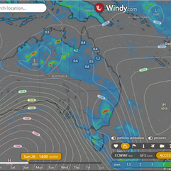
State maps by Windy (Windy.com)
Weather forecast supplemented by Bureau of Meteorology (bom.gov.au)
Rainfall daily totals (https://meteologix.com/ )
AccuWeather (https://www.accuweather.com/)
Nine Weather (https://www.9news.com.au/weather)
Wally's Weather provides professionally researched data and information. Andrew aka 'Wally' has over 20 years of experience in meteorology research and data analysis. In 2023 finished top 4 for the AMOS national weather forecasting competition. The content here is provided as educational information aimed at providing the community and businesses with the tools required to determine local-based forecasts. IMPORTANT: The forecasts and information posted should never be used on their own to make business decisions as local influences.


Comments