Morning Weather - November 29 - Wally's Weather Australia
- Nov 28, 2023
- 4 min read
This weather update is brought to you by Genesis Electrical NQ

Genesis Electrical NQ
We can Solve all of your Electrical, Air Conditioning and Solar needs!
Green Energy Initiative
Phone: 1300 443 637
Email: info@genesislec.com
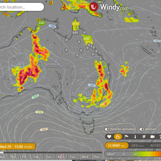
Storms special report
The number of warnings shows how widespread the storms are today. Deep troughs moving east, bringing intense rain, storms, and gusty winds to SE QLD, NSW, and VIC. High pressure causing showers in TAS's east and clearing much of SA. West trough causing scattered showers and storms across central Australia, the NT, and eastern and southern WA.
WEATHER WARNINGS
Strong Wind Warning for Far North West and Central North coasts. Cancellation for South West and Central West coasts.
Strong Wind Warning for Port Phillip, Gippsland Lakes & West, Central, Central Gippsland, and East Gippsland coasts.
Strong Wind Warning for Sydney and Illawarra coasts.
Severe Weather Warning (Heavy Rainfall And Damaging Winds) for parts of West and South Gippsland, Central and South West.
Severe Thunderstorm Warning (Damaging Winds And Large Hailstones) for parts of Maranoa and Warrego.
Severe Storm Warning (Rain & Winds) CW Slopes/Plains & Illawarra, S Cst, S Tablelands, SW Slopes, L Western, U Western, C Tablelands.
Severe Thunderstorm Warning (Heavy, Locally Intense Rainfall) for South West, South Coastal, Great Southern & Central Wheat Belt districts.
Strong Wind Warning for Pilbara Coast West & Esperance and Eucla coasts. Cancellation for Albany Coast.
Downy Mildew Advice for Mid North, Mount Lofty Ranges, Riverland, Murraylands and Upper South East.
Hazardous Surf Warning for Wednesday for Batemans and Eden coasts.
Severe Weather Warning (Heavy Rainfall And Damaging Winds) for South Coast and parts of Illawarra and Snowy Mountains.
Sheep Graziers Warning Illawarra, Southern Tablelands, CW Slopes & Plains, South West Slopes, Riverina, Snowy Mountains, ACT & South Coast.
Sheep Graziers Warning for Central, West and South Gippsland and East Gippsland.
Cancelled Sheep Graziers Warning E Eyre, Lower Eyre Peninsula, Mid North, Yorke Peninsula, Mount Lofty Ranges & Kangaroo Island.
Strong Wind Warning Spencer Gulf, Gulf St Vincent, Invest St & South Central, Upper South East & L SE coasts. Cancelled Central Coast.
Initial Flood Watch For Gippsland And Parts Of North East And South West Victoria.
Flood Watch For Parts Of The New South Wales Illawarra Coast, South Coast Rivers, Inland Central West Rivers And South West Rivers.
Moderate Flood Warning For Wallam Creek And Flood Warning For Mungallala Creek.
Major Flood Warning For The Moonie River.
Minor Flood Warning For The Barcoo River.
Minor Flood Warning For The Paroo River (Qld).
Minor Flood Warning For The Paroo River (Nsw).
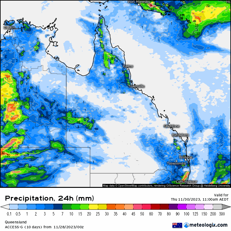
ECMWF Storm 4pm | ECMWF Accumulated Rain 3 Days | ACCESS QLD 8 x 24 hour Rainfall


National
High north of New Zealand maintains weak ridge along east coast, directs humid air into
broad trough over interior state. Low-pressure system moves east across southeastern Australia, dragging trough across southern Queensland and off southeast coast, brings warmer and drier airflow across south of state. Trough lingers over central districts on Thursday, drifts back southward and westward from Friday, brings return to humid and showery conditions across eastern and interior Queensland.


State
A north high near New Zealand will keep a weak ridge along the east coast and bring humid air into an interior trough. A low-pressure system will move across southeastern Australia, dragging the trough over Queensland and bringing warmer and drier wind from the west. The trough will stay over central districts on Thursday before drifting south and west again from Friday, bringing back humid and showery weather to eastern and interior Queensland.


4-day
Wednesday: Most of the state will have scattered showers and thunderstorms, becoming widespread at times. There may be severe thunderstorms in the south and southeast. The northern Peninsula will have showers and thunderstorms, while the far west will be partly cloudy. Winds will be light to moderate from the northwest to northeast, with a west to southwesterly wind change in the evening.
Thursday: Thursday: Scattered showers and thunderstorms across most of the state with showers along the east coast. Warmer temperatures in the east and southeast, cooler in the west. Dry winds and high fire danger in southeast inland and southern interior. Heatwave conditions in parts of tropical northeast, central, and southeast coasts.
Friday: Scattered showers and thunderstorms across the state, becoming more widespread in the central interior. Isolated showers along the east coast above St. Lawrence. Above-average maximum temperatures in the east, well above average in the southeast, and near or below average in the interior. Elevated fire danger in the far west. Local severe heatwave conditions in parts of the tropical northeast, central, and southeast coasts.
Saturday: Scattered showers and thunderstorms across the state, especially in southeastern Queensland, with isolated showers and thunderstorms in the eastern Peninsula. Mostly sunny in the far southwest. Higher temperatures. Some areas experiencing severe heatwave conditions in the tropical northeast.


Click here to support to Wally's Weather
National maps by Weatherzone (weatherzone.com.au)
State maps by Windy (Windy.com)
Weather forecast supplemented by Bureau of Meteorology (bom.gov.au)
Rainfall daily totals (https://meteologix.com/ )
AccuWeather (https://www.accuweather.com/)
Nine Weather (https://www.9news.com.au/weather)
Wally's Weather provides professionally researched data and information. Andrew aka 'Wally' has over 20 years of experience in meteorology research and data analysis. In 2023 finished top 4 for the AMOS national weather forecasting competition. The content here is provided as educational information aimed at providing the community and businesses with the tools required to determine local-based forecasts. IMPORTANT: The forecasts and information posted should never be used on their own to make business decisions as local influences.


Comments