Morning Weather - November 3 - Wally's Weather Australia
- Nov 3, 2023
- 3 min read
This weather update is brought to you by Genesis Electrical NQ

Genesis Electrical NQ
We can Solve all of your Electrical, Air Conditioning and Solar needs!
Phone: 1300 443 637
Email: info@genesislec.com
Big Shout members check the Long-Range Forecast Post for updates.
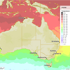
National
Weak ridge along east coast persists next few days, slow moving inland trough. Trough deepens from Friday, increasing showers and thunderstorms in south and central districts. Trough may drift eastwards over southeast inland this weekend, then push west
towards western Queensland next week.


State
Weak ridge remains along east coast, slow-moving trough deepens Friday with increased rain and storms in southern and central districts. Southern part of trough may move eastwards this weekend before pushing west towards western Queensland next week.


4-day
Friday: Isolated showers in Capricornia, Wide Bay and Burnett, Central Highlands, and northern Maranoa with possible thunderstorms inland. Isolated showers or thunderstorms in far west south of Urandangi and west of Boulia. Partly cloudy in South East Queensland, mostly clear elsewhere with areas of smoke haze possible over central and southeastern districts. Light to moderate southerly winds in southwester, central, and southern interior. Light to moderate southeast to northeasterly winds elsewhere, fresh at times in the early evening along Herbert, Lower Burdekin, and Capricornia coasts.
Saturday: Isolated rain and storms in central and southern districts south of Bowen, east of Barcaldine to St George. Showers scattered over inland central and southeast Queensland, widespread at times in the southeastern Darling Downs and Granite Belt. Very isolated showers returning to the east coast north of Townsville. Possible isolated shower or storm in the Gulf Country. Risk of severe thunderstorms in the southeastern interior. Partly cloudy elsewhere. Above average temperatures in the northwest, central and northern interior, near or below average in the southeast.
Sunday: Scattered showers & thunderstorms in central/southern districts. Widespread showers in SE QLD. Isolated showers on east coast. Possible shower/storm in Gulf Country. Risk of severe thunderstorms in SE QLD. Partly cloudy elsewhere. Max temps above avg in northwest, below avg in southeast, near avg elsewhere. Min temp near/below avg in western & northern QLD.
Monday: Some showers and thunderstorms in central and southern districts south of Mackay and east of Longreach to Charleville. Isolated showers along the east coast north of Mackay and south of Cooktown with the chance of a thunderstorm inland. Showers may become more widespread at times in South East Queensland. Partly cloudy elsewhere. Temperatures near or above average in the west, below average in the southeast, and near average elsewhere. Minimum temperature near or below average in western and northern Queensland.


Townsville
Min 18°C, Max 29°C, Mostly sunny. Chance of rain: 0%. Light winds, becoming NE 20-25 km/h in the morning, then E 20-30 km/h in the middle of the day.
Herbert and Lower Burdekin
Min 20°C, Max 41°C, Sunny. Chance of rain: 0%. Winds NE to SE 15-20 km/h, tending SE to SW 15-25 km/h in the early afternoon, then NE to SE in the late evening.
North Tropical Coast and Tablelands
Min 18°C, Max 32°C, Partly cloudy. Chance of rain: 0%. Winds E 20-30 km/h.
Cairns
Min 23°C, Max 41°C, Mostly sunny. Chance of rain: 0%. Light winds, becoming E 20-30 km/h in the morning, then light in the middle of the day.
Mackay
Min 20°C, Max 29°C, Partly cloudy. Chance of rain: 5%. Winds E 15-20 km/h, becoming light before dawn, then E to NE 15-20 km/h in the morning.
Northern Goldfields
Min 21°C, Max 39°C, Mostly sunny. Chance of rain: 0%. Winds E to NE 15-25 km/h.
Mt Isa
Min 23°C, Max 41°C, Mostly sunny. Chance of rain: 0%. Light winds, becoming E 15-25 km/h in the morning, then SE 15-20 km/h in the early afternoon.
Click here to support to Wally's Weather
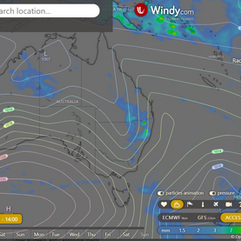
National maps by Weatherzone (weatherzone.com.au)
State maps by Windy (Windy.com)
Weather forecast supplemented by Bureau of Meteorology (bom.gov.au)
Rainfall daily totals (https://meteologix.com/ )
Wally's Weather provides professionally researched data and information. Andrew aka 'Wally' has over 20 years of experience in meteorology research and data analysis. In 2023 finished top 4 for the AMOS national weather forecasting competition. The content here is provided as educational information aimed at providing the community and businesses with the tools required to determine local-based forecasts. IMPORTANT: The forecasts and information posted should never be used on their own to make business decisions as local influences.


Comments