Morning Weather - September 24 - Wally's Weather Australia
- Sep 24, 2023
- 3 min read
This weather update is brought to you by Gecko Interior

Welcome to Gecko Interiors, a fun and colourful gift and homewares store based in tropical North Queensland, Australia. . Whether you're a local shopping from home, or dropped into my store while on a recent holiday to Townsville (with no room left to take everything back in your suitcase! ), let us take care of delivering to you.
Dam Filler is an educational game ideal for homeschooling. This is a locally produced board game, based around Australian weather and teaches about the Dry Tropics including STEM concepts of Wind Speed, Direction, Relative Humidity and Pressure Systems. You don't need to know anything about that to play, you just play and learn as you go. The infographic left shows the steps each player takes during their turn. Watch the video on how to play.
National
Tasmania's near high extends ridge, weak trough lingers over Channel Country District this weekend. High moves to Tasman Sea, drifts north, weakens. Second high merges on Wednesday. Trough moves southwest, over Queensland, weakens. New high extends ridge next Saturday.


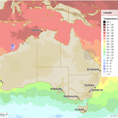
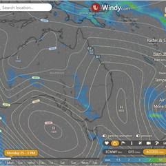
State
A high extends over Tasmania with a weak trough. High will move north and weaken. Second high moves in on Tuesday and merges with the first on Wednesday. Trough system moves through state on Wednesday and weakens by Friday. Another high moves in on Saturday.


4-day
Monday: Isolated showers on east coast north of Gladstone, scattered showers on North Tropical Coast. Isolated showers and chance of thunderstorm in southwest. Mostly sunny elsewhere. Above average temperatures in southwest, near average elsewhere.
Tuesday: Isolated showers in east coast north of Mackay, Torres Strait, scattered showers in North Tropical Coast. Mostly sunny elsewhere. Maximum temperatures near average in north of Hughenden and eastern districts, above average elsewhere. Minimum temperatures well above average in the southwest, near average elsewhere.
Wednesday: A few showers in the east coast, Torres Strait, and North Tropical Coast. Some showers and a chance of thunderstorms in southwest and southern interior. Mostly sunny elsewhere. Above average maximum temperatures in the south and well above average in the southern interior. Above average minimum temperatures in the southwest, near average elsewhere.
Thursday: Thursday: Isolated showers and possible thunderstorm in southeast. Isolated showers along east coast, becoming scattered at times. Mostly sunny elsewhere. Above average temps in south, well above average in southern interior. Above average min temps in southwest, near average elsewhere.


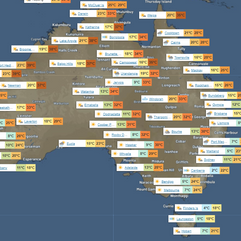
Townsville
Max 28°C, Partly cloudy, 5% chance of rain. Partly cloudy. SE winds 15-20 km/h, tending NE-SE 25-35 km/h midday, then light late evening.
Herbert and Lower Burdekin
Max 27°C, Partly cloudy, 5% chance of rain. Slight shower chance north, near zero elsewhere. SE winds 15-20 km/h, becoming E 25-35 km/h in the morning.
North Tropical Coast and Tablelands
Max 27°C, Partly cloudy, 20% chance of rain. Med chance of coastal showers, slight elsewhere. E-SE winds 25-40 km/h.
Cairns
Max 28°C, Shower or two, 50% chance of rain. Partly cloudy. Med chance of showers. SE winds 20-25 km/h, increasing to 25-40 km/h AM, then becoming light late evening.
Mackay
Max 25°C, Partly cloudy, 20% chance of rain. Partly cloudy. Slight shower chance. SE winds 25-35 km/h.
Northern Goldfields
Max 31°C, Wind easing, sunny, 0% chance of rain. Sunny. E-NE winds 15-25 km/h, becoming E 25-40 km/h AM.
Mt Isa
Max 33°C, Mostly sunny, 0% chance of rain. NE winds 20-30 km/h, becoming light early PM.
Click here to support to Wally's Weather
National maps by Weatherzone (weatherzone.com.au)
State maps by Windy (Windy.com)
Weather forecast supplemented by Bureau of Meteorology (bom.gov.au)
Rainfall daily totals (https://meteologix.com/ )
Wally's Weather provides professionally researched data and information. Andrew aka 'Wally' has over 20 years of experience in meteorology research and data analysis. The content here is provided as educational information aimed at providing the community and businesses with the tools required to determine local-based forecasts. IMPORTANT: The forecasts and information posted should never be used on their own to make business decisions as local influences.


Comments