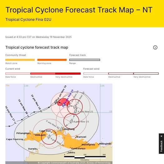
TC Fina Cat 2 (19/11 5pm)
- Nov 19, 2025
- 2 min read
Tropical Cyclone Fina – Category 2 update (NT) right after i posted cat 1. Argh.
Tropical Cyclone Fina (Cat 2) is sitting over the Arafura Sea and is expected to turn south towards the northern Top End coast during Thursday, then track southwest on Friday and Saturday along the northwest NT coast.
Who’s in the watch area?
From Cape Fourcroy to Milingimbi, including the Tiwi Islands, Cobourg Peninsula, Gunbalanya, Cape Don, Warruwi and Maningrida.
What to expect (from later Thursday into the weekend)
Gales with damaging wind gusts to ~120 km/h along the northwest Top End coast.
Destructive gusts to ~135 km/h possible between Cape Don and Warruwi as Fina nears the coast.
Heavy rain and flash flooding risk between the Tiwi Islands and Milingimbi.
Dangerous storm tide and large waves about low-lying coastal areas if the centre crosses near high tide.
Now is the time for people in the watch area to review your cyclone plan and stay up to date with official warnings from BOM and NTES (132 500 / SecureNT website).

Latest forecast
Lead time from now | JTWC lat (°S) | JTWC lon (°E) | BOM lat (°S) | BOM lon (°E) | Approx distance between points | Simple take |
0 hr | 9.7 | 132.6 | 9.5 | 132.6 | ~20 km | JTWC a bit further south |
12 hr | 9.8 | 133.3 | 9.6 | 133.0 | ~40 km | JTWC south and slightly east |
24 hr | 10.1 | 133.7 | 9.6 | 133.3 | ~70 km | JTWC clearly south & east |
36 hr | 10.6 | 133.7 | 9.9 | 133.4 | ~85 km | JTWC further south & east |
48 hr | 11.2 | 133.3 | 10.6 | 133.1 | ~70 km | JTWC south & a touch east |
72 hr | 12.1 | 132.1 | 11.6 | 131.6 | ~80 km | JTWC south & east of BOM |


Comments