TC Fina JTWC (19/11 7pm)
- Nov 19, 2025
- 2 min read
Tropical Cyclone Fina – JTWC update (north of the NT)
This map and track come from the JTWC – the Joint Typhoon Warning Center, a US Navy and Air Force centre based in Hawaii that tracks tropical systems across the Indian and Pacific Oceans. It has a very good reputation for our part of the world.
BOM is still our official source for Australian warnings and advice – emergency services follow BOM, and so should we. JTWC is a useful second opinion.
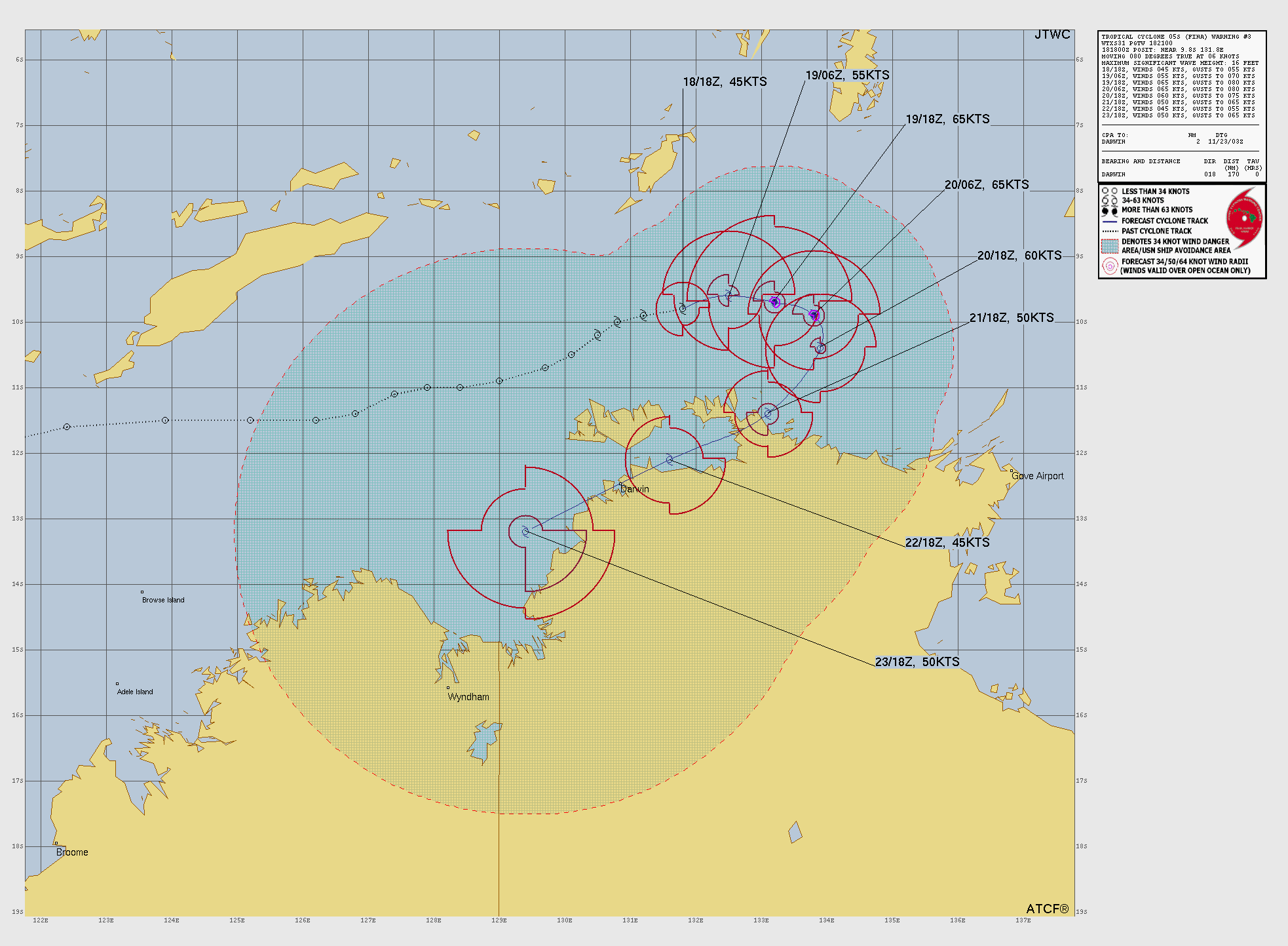
Where Fina is now
Sitting over the Timor Sea, roughly 370 km north-north-east of Darwin.
Moving east-north-east at about 13 km/h.
Winds near the centre are around 50 knots (about 90–95 km/h) over the ocean, with the cloud wrapping clockwise into the centre as you can see on the satellite image.
Seas out in the deep water are around 5 metres.
The environment over the warm sea (around 30–31 °C) is still fairly friendly for it, so a bit more strengthening is possible in the short term.
What JTWC expects next
For the next 12 hours or so, Fina is expected to keep sliding east-north-east, still offshore.
After that, the steering winds start to fight each other, so it should slow down and begin to hook back towards the south-west, then track south-west across the rest of the outlook, eventually brushing the northern NT and far north WA coastlines.
As it nears the coast it runs into stronger winds higher up and drier air, so JTWC expects it to gradually weaken through the weekend, with a possible small pulse of strengthening again if it slips back over the Timor Sea early next week.
There’s still wiggle room of more than 100 km on exactly where the centre runs later in the week – some models keep it a bit further offshore, others tuck it more along the coast. That’s normal at this range.
What’s changed from JTWC’s last forecast?
JTWC themselves say there are no major changes this time. The overall story is the same – east-north-east for now, then a turn back towards the south-west with a slow weakening trend as it nears the northern coast.
For anyone in the Top End or far north WA, it’s one to keep an eye on rather than worry about at this stage.
Please follow the official Bureau of Meteorology warnings and any advice from local emergency services. I’ll keep posting updates as both BOM and JTWC refresh their guidance.


Current Forecast
Lead time from 190600Z | Valid time (Z) | Latitude (°S) | Longitude (°E) | Max wind (kt) | Max wind (km/h, ~) |
0 hr (analysis) | 190600Z | 9.7 S | 132.6 E | 55 kt | 102 km/h |
12 hr | 191800Z | 9.8 S | 133.3 E | 60 kt | 111 km/h |
24 hr | 200600Z | 10.1 S | 133.7 E | 65 kt | 120 km/h |
36 hr | 201800Z | 10.6 S | 133.7 E | 60 kt | 111 km/h |
48 hr | 210600Z | 11.2 S | 133.3 E | 55 kt | 102 km/h |
72 hr | 220600Z | 12.1 S | 132.1 E | 50 kt | 93 km/h |
96 hr | 230600Z | 12.8 S | 130.4 E | 45 kt | 83 km/h |
120 hr | 240600Z | 13.4 S | 128.8 E | 55 kt | 102 km/h |


Comments